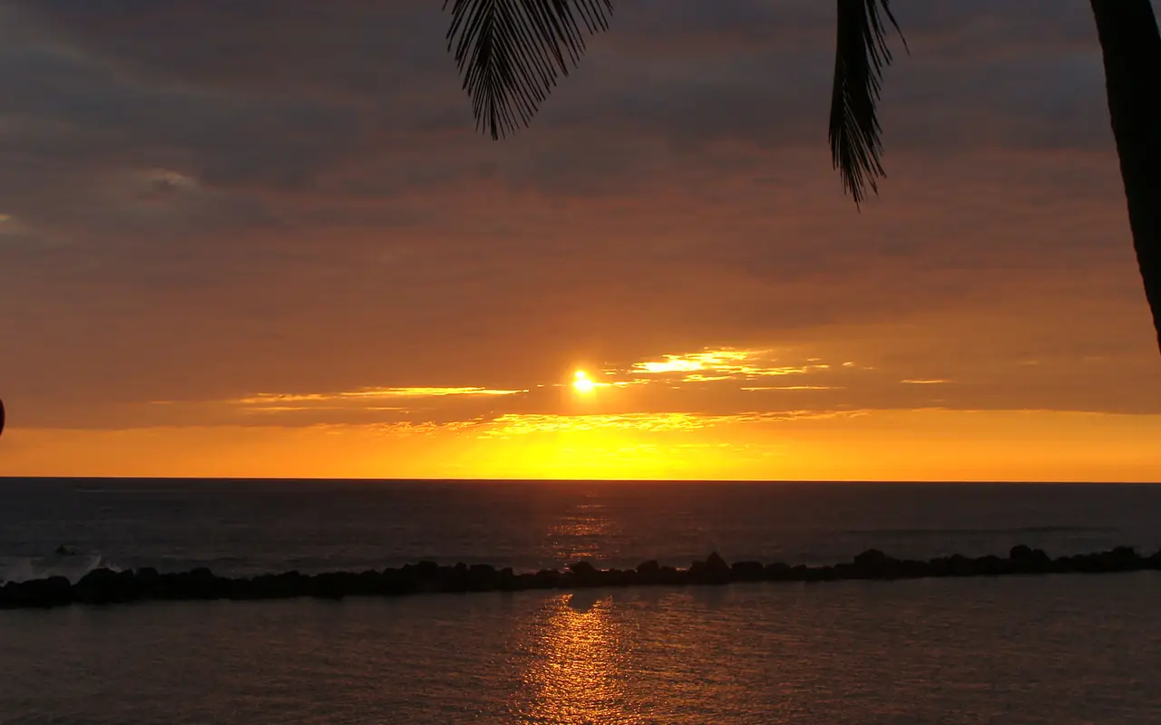
Sunset over the Pacific at Salinitas, El Salvador

Weather and timing

Best time to visit El Salvador

Compare temperature, rain, and humidity through the year to plan your drives, volcano hikes, beach days, and highland stays.

Photo: Snakeyes

November to February

Easiest all-round window

These months often make road trips and outdoor city days easier, with less chance of regular afternoon rain. Highlands can feel noticeably cooler than the coast, especially early and late in the day, so pack one light layer rather than assuming tropical heat everywhere.

March and April

Drier days, with more heat to plan around

Road and hiking plans may still be straightforward, but heat exposure matters more. Put exposed walks and hikes early, carry more water than a city day seems to require, and choose shade or pool time for the middle of the afternoon. Easter travel can increase demand, so verify accommodation and transport early.

May to August

Green landscapes and flexible afternoons

Rainy season does not mean all-day rain every day. Build important outdoor plans into the morning, keep an afternoon alternative for wet weather, and avoid making a sunset transfer the only way the route works. MARN notes that multi-day dry spells can occur during the rainy season, particularly around July or August in some climate patterns, so do not plan from a generic rainfall chart alone.

September and October

Leave extra room for weather changes

Keep mountain viewpoints, waterfalls, boat outings, and long road days movable. Check forecasts and official alerts daily, choose refundable arrangements when weather sensitivity is high, and avoid routes that depend on driving an unfamiliar mountain road after dark.
Choose by priority

The best month changes with the trip

Weather is only part of the choice. Surf ability, holiday demand, photography goals, tolerance for heat, and the amount of route flexibility matter just as much.

Volcano hiking

Favor an early start and a current access check in every season. Wind, visibility, volcanic monitoring, and park operations can override a seasonal expectation.

Surf

Choose by ability and current swell, not by a promise that one season is “best.” Beginners need an appropriate break, instructor, tide, and conditions on the day.

Ruta de las Flores

Dry weather simplifies town walks; wetter months can make the highlands lush. Keep waterfalls optional when access, storms, or trail conditions are uncertain.

Beaches and boats

Check the coastal forecast, tides, local flags, currents, and operator decision. Sunshine alone does not establish safe swimming or boating conditions.

What to pack

Pack for elevation and rain, not one temperature

  • Breathable clothing and dependable sun protection year-round
  • A light rain shell and dry bag or waterproof pouch in rainy months
  • Footwear with grip for volcanic gravel, wet stone, and uneven town streets
  • A light layer for highland mornings and air-conditioned transport
  • Offline weather, map, reservation, and emergency information
  • A flexible activity that does not depend on a clear crater or ocean conditions

48 hours before

Switch from climate to forecast

The month helps choose the trip. The official short-range forecast helps choose tomorrow’s hike, drive, surf lesson, or boat outing. Recheck again the morning of a weather-sensitive activity.

Open the MARN 48-hour forecast

Twenty years in one view

Temperatures vary less than rain and humidity

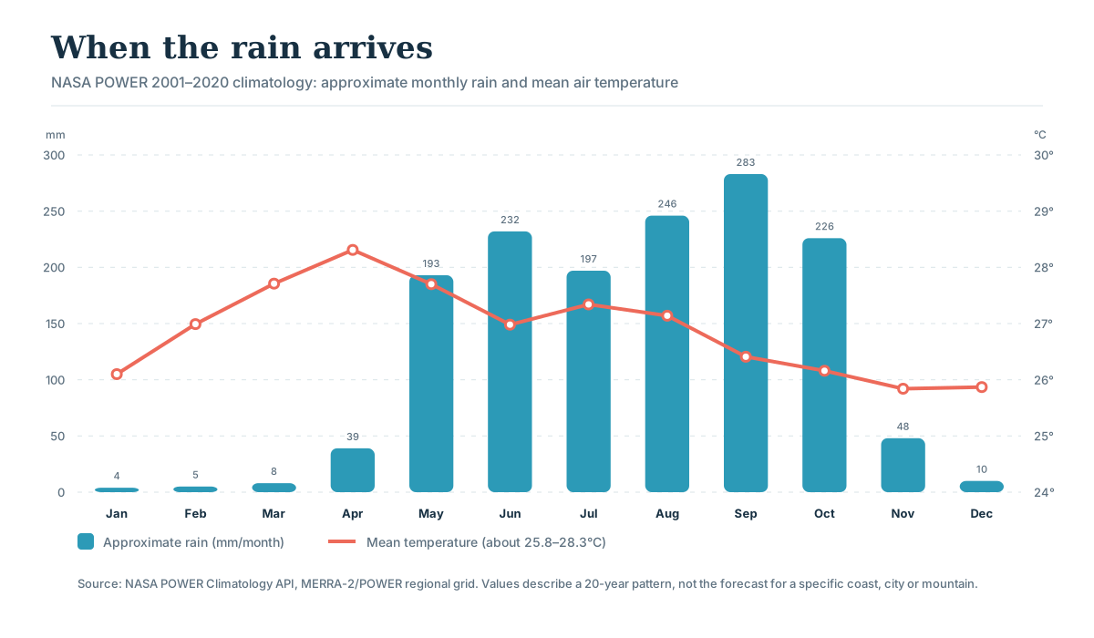
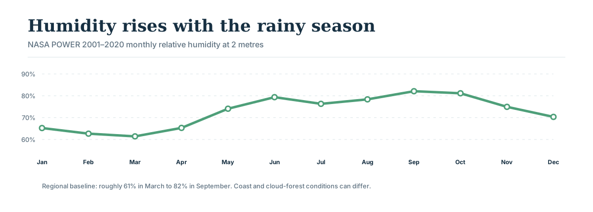
The NASA POWER 2001–2020 climatology shows a warm regional baseline all year. The practical change is moisture: approximate rain rises from almost nothing in January through March to 193 mm in May and peaks around 283 mm in September. Relative humidity follows, climbing from roughly 61% in March to 82% in September.

Use this to choose the month and pace. Do not use it to decide whether tomorrow’s crater will be clear. NASA’s grid is regional, and El Salvador’s coast, city basins and western highlands can feel very different on the same date.

Monthly climate chart for the San Salvador-area NASA grid showing approximate rain of 4 millimetres in January, 5 in February, 8 in March, 39 in April, 193 in May, 232 in June, 197 in July, 246 in August, 283 in September, 226 in October, 48 in November and 10 in December; mean temperature stays near 26 to 28 degrees Celsius
Approximate monthly rain is NASA’s corrected precipitation rate multiplied by calendar days and rounded. The temperature line uses its own right-hand °C scale.
Monthly relative humidity chart showing humidity near 61 to 65 percent from January through April, rising above 74 percent from May and peaking around 82 percent in September
Humidity affects how warm a day feels and how quickly clothes dry. Use it to decide what to pack, not to predict rain at a particular hour.

Month by month

Which season feels better to you?

The table uses one consistent regional dataset so you can compare months. Temperatures are monthly means, not daytime highs. Rainfall is an approximate monthly total. Always switch to SNET’s forecast for the actual trip.

Swipe horizontally to compare all columns →

Monthly temperature, approximate rainfall, humidity and trip-planning guidance for El Salvador
MonthMean °CRain mmHumidityHow to plan it
January26.1°465%Easy road and town weather; pack a highland layer.
February27.0°563%Dry and less humid; good for visiting several regions.
March27.7°861%Hot, dry afternoons; hike and walk early.
April28.3°3965%Warmest mean; allow for Easter demand and first storms.
May27.7°19374%Landscapes green quickly; protect outdoor mornings.
June27.0°23279%Wet and humid; keep transfers and trails flexible.
July27.3°19776%A drier spell can occur, but never build the trip around it.
August27.1°24678%Good green-season travel with rain plans each day.
September26.4°28382%Wettest month in this dataset; leave extra room for weather changes.
October26.2°22681%Stay flexible around roads, boats and mountain views.
November25.8°4875%A useful transition into easier road-trip weather.
December25.9°1070%Dry and popular; book holiday dates earlier.

Western highlands run cooler

NASA’s western-highland grid point averages 24.1°C across the year, roughly 2.8°C below the San Salvador-area regional baseline. Ataco mornings and a volcano start deserve a layer even when the coast feels hot.

Rain totals do not describe the whole day

A wet month can still contain bright mornings; a dry month can still bring an unusual storm. Put the most weather-sensitive plan first and keep one nearby alternative.

Climate evidence and live checks · reviewed 25 July 2026

Use the dataset for seasons and SNET for tomorrow

The charts and table use NASA POWER’s 2001–2020 climatology at a San Salvador-area grid point. SNET/MARN remains the responsible source for current Salvadoran weather, coastal outlooks, hazards and volcano monitoring.

Good to know

A few useful answers

Answers about dry and rainy seasons, surf, festivals, heat, and weather changes.

Who needs to think most carefully about the season?

Travelers planning volcano hikes, surfing, festivals, road trips, or outdoor days during the rainy season will get the most from this guide.

What can change close to travel?

Rainfall, storms, trail access, surf, festival dates, and road conditions can all change, so check the relevant local source near departure.

How early should I choose dates?

Book early for major festivals or fixed school-holiday dates. Otherwise, choose the season first and leave individual outdoor days flexible.