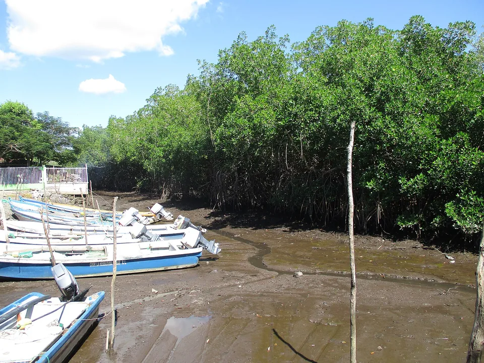
Boats beside mangroves in the Jaltepeque estuary

Transport without stress

Getting around El Salvador

Compare regions and road distances before choosing a driver, rental car, shuttle, or bus.

Photo: K3mejia041018

Private driver

Best for a short, mixed-region trip

A driver makes the day easier when it includes luggage, early trail access, archaeology, or a hotel change. Before paying, get the date, pickup, route, waiting time, parking, luggage capacity, and overtime terms in writing. Ask whether the same vehicle covers the day and what happens after a delay or mechanical problem.

Rental car

Best for confident, flexible road-trippers

A rental works for beach-to-highland routes when the driver is comfortable with unfamiliar traffic and variable roads. Compare total insurance rather than the headline rate. At pickup, record every panel, tire, wheel, window, fuel level, and warning light; confirm roadside support, deposit, additional-driver rules, and return process.

Shared shuttle

Best for established visitor bases

Shuttles can simplify airport, capital, and popular beach connections, but value depends on the exact pickup, minimum passengers, luggage policy, and cancellation terms. Confirm whether “door to door” means your property or a meeting point. A cheap seat is not useful if it forces an extra taxi or misses a flight buffer.

Public bus

Best for flexible travelers with time

Identify the route number, destination sign, correct terminal, likely transfer, last practical departure, luggage setup, and arrival plan before boarding. Do not treat a map app timetable as guaranteed. VMT is the national transport authority, but confirm the final route, departure, and fare locally because operations change.
Transfer planning

Plan around the one time you cannot miss

The right departure time depends on the flight, trail, tour, check-in, or daylight window at the other end. Leave room around fixed times first and add optional stops only after the transfer works on its own.

Airport day

Pre-arrange late pickups, share the flight number, and agree on a meeting point. For departure, use the airline’s check-in target plus a separate road buffer.

Volcano day

Work backward from the current official hike departure. Confirm access, driver waiting, weather, and the backup plan the evening before.

Coast day

Weekend activity can change the route. Arrive with daylight and do not leave valuables visible in a parked vehicle.

Highland day

Rain, fog, curves, and town stops add time. A waterfall, five towns, and a coast transfer will not fit comfortably into one day.

Before every ride

A practical confirmation list

  • Exact pickup pin and recognizable landmark
  • Driver or operator name, phone, and vehicle details
  • Price, currency, inclusions, payment, and cancellation terms
  • Luggage, child-seat, accessibility, and surfboard capacity
  • Offline map, destination address, and charged phone
  • A plan for delays, poor reception, rain, and late check-in

Allow time between stops

A short map distance can still create a long day

Two strong regional stops usually beat four rushed ones. When a transfer includes luggage and hotel check-in, treat it as a primary part of the itinerary rather than empty space.

See the shape of the trip

Plan the country in regions

Most first trips are built from three clusters: the airport/capital/central corridor, the western volcano-and-coffee loop, and the Pacific coast. El Cuco and La Unión lie far enough east of San Salvador to deserve their own stay rather than a quick day trip.

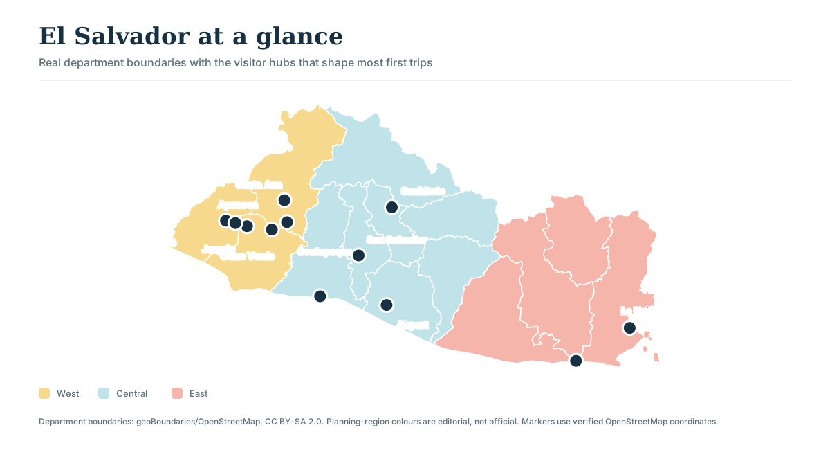
The map below uses real department boundaries from geoBoundaries/OpenStreetMap and verified place coordinates. The west, central and east colors are editorial trip-planning regions, not official administrative zones.

Map of El Salvador with real department boundaries and visitor hubs marked: Ataco, Santa Ana, Cerro Verde, Lake Coatepeque, El Tunco, San Salvador, Suchitoto, the international airport, El Cuco and La Unión
Use the map to choose overnight clusters. A pin’s proximity on a national map does not replace the road distance or transfer buffer below.

Central

Airport, capital and Suchitoto

San Salvador works well for city time and the first or last night. Suchitoto deserves its own day or evening away from an airport transfer.

West + coast

Volcano, lake, coffee towns and El Tunco

This is the classic loop. Sleep west for an early volcano day, then move through Ataco before dropping to the coast.

East

El Cuco and Gulf of Fonseca

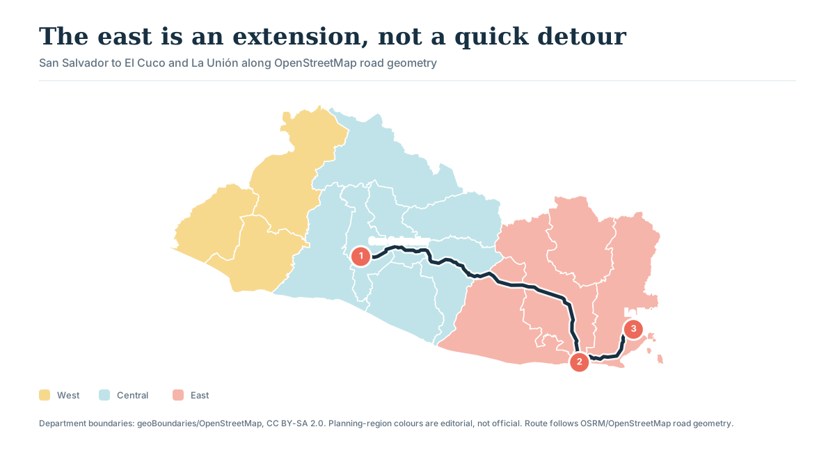
The east is a separate leg of the trip. San Salvador to El Cuco is roughly 173 km before traffic, weather, meals, and check-in stops.

How the roads connect

The classic loop is compact; the eastern extension changes the pace

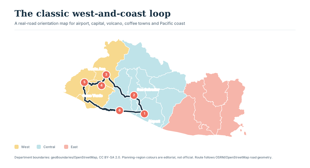
These diagrams follow OSRM routes over OpenStreetMap road data. They are orientation tools, not turn-by-turn navigation: current traffic, closures and your exact hotel pin can change the route.

Road-route map for a classic El Salvador loop connecting the international airport, San Salvador, Santa Ana, Cerro Verde, Ataco and El Tunco

Classic west-and-coast loop

A comfortable five-to-seven-day outline through the capital, Santa Ana, coffee towns, and the coast without repeated cross-country drives.

Road-route map from San Salvador east to El Cuco and La Unión

Eastern extension

Spend a few nights in the east if you go. Do not add it to a short western itinerary just because the country looks small.

Road distances

Distance tells only part of the story

These point-to-point estimates were retrieved from OSRM/OpenStreetMap on 25 July 2026. Model times do not include congestion, rain, roadworks, parking, food, viewpoints, airport formalities or finding the hotel.

Road distances and routing-model times between common visitor stops in El Salvador
RouteRoad distanceEstimated drive timeWhat changes the choice
Airport → San Salvador39.2 km~46 minAdd flight, baggage and city-traffic margin.
Airport → El Tunco39.5 km~39 minPre-arrange late arrivals and share the flight number.
San Salvador → El Tunco42.5 km~48 minWeekend coast traffic can change the feel of this short move.
San Salvador → Suchitoto45.6 km~52 minA day trip works; one night gives the town breathing room.
San Salvador → Santa Ana63.9 km~61 minSleep west before an early volcano day.
Santa Ana → Cerro Verde27.3 km~39 minAllow mountain-road and park-check-in time.
Cerro Verde → Coatepeque23.3 km~37 minKeep the lake optional after a weather-sensitive hike.
Santa Ana → Ataco44.8 km~47 minThe route becomes a day when coffee and town stops are added.
El Tunco → Ataco125.3 km~117 minTreat this as the day’s primary transfer, not empty time.
San Salvador → El Cuco172.7 km~166 minPlan it as a half-day move with an eastern stay.
El Cuco → La Unión45.2 km~47 minWork backward from any verified boat or port commitment.

Plan around the time you cannot miss

Plan the fixed moment first, then work backward

Leave enough time to arrive ready for your flight, hike, boat trip, or check-in rather than relying on the shortest app estimate. Flights, official hike departures, boat checks, and hotel deadlines set the day’s timetable.

  1. 1

    A few well-placed overnights

    Think in broad areas: center, west and coast, then east if you have time. Removing a hotel change often improves the trip more than adding another stop.

  2. 2

    Leave room around fixed times

    The airline, park, or operator should provide the current time; an old blog timetable is not reliable enough.

  3. 3

    The easiest option may change by day

    Luggage, language, children, surfboards, parking and confidence often matter more than price alone.

  4. 4

    Allow time for stops and delays

    Traffic, rain, viewpoints and lunch are part of the trip. Do not schedule every saved minute.

Local orientation sketch, not a Google Maps preview. Google Maps loads only after you open it.

Open separately in Google Maps

Map, route and authority sources · reviewed 25 July 2026

Map estimates for planning, live sources before leaving

Place coordinates were checked through Nominatim. Department boundaries come from geoBoundaries’ OpenStreetMap-derived 2021 ADM1 file. Distances and drive lines use OSRM over OpenStreetMap road data. Transport operations, fares and departures still need direct confirmation.

Airport connection

Choose the first ride before comparing the rest

Compare drivers and rental cars for your arrival time and first night, with advice on road travel, phone service, and the return to the airport.

Plan airport transport →

Good to know

A few useful answers

Answers about buses, drivers, rentals, travel times, and moving between regions.

Which way of getting around suits the trip?

This guide helps travelers compare buses, shared transport, private drivers, and rental cars for the regions they want to visit.

What should I confirm before a transfer?

Confirm the pickup point, departure time, full price, luggage space, expected stops, contact number, and what happens if plans change.

When should transport be booked?

Arrange airport rides, early volcano pickups, and long interregional transfers first. Short local journeys can often remain flexible.